Leveraging Digital Elevation Models for Data-driven Assessment of Evolutionary Damage in Built Heritage
Department of Architecture, University of Ferrara, Italy
Email: manlio.montuori@unife.it
Abstract. The paper aims to illustrate how implementing a digital elevation model enables an extensive comprehension of the current deformation crisis state of overturning masonry in the context of a case study. The approach explores the interoperability challenges and details in scan-to-HBIM processes, thereby elucidating how HBIM models can support operations that are intended to maintain and preserve extant historic assets despite the persistent challenges. This illustrative investigation underscores the effectiveness of applying digital technologies to advance the conservation and management practices of built cultural heritage, particularly in addressing structural concerns associated with historic masonry. The information should involve meticulous knowledge, anamnesis, visual inspection, and instrumental measures, as dataset accuracy is crucial in architectural heritage, where surveyed objects exhibit complex geometries and significant deformation. It is a deliberate, synthetic operation that develops a structural model for assessment. A key finding of the present paper is that the precision and detail of the model determine the accuracy of structural analysis results, emphasising the importance of accuracy consideration to achieve meaningful and reliable results. As a consequence, the building assessment demonstrated which parts of the building’s façades were overturning while identifying the thorough kinematic phenomena progressively acting.
Keywords: Built heritage conservation, Damage assessment, Kinematic phenomena, Out-of-plane overturning mechanism, Scan-to-HBIM.
1. Introduction
Structural analyses of buildings often rely on simplified geometric models to expedite numerical computations, minimise processing demands, and streamline workflows. While this simplification can be both valid and practical, it is critical to ensure that such reductions do not compromise the reliability of the analysis results. The fidelity of the model plays a pivotal role in achieving accurate outcomes, particularly when capturing the essential physical behaviours and structural responses of the system under study. This requirement becomes even more pronounced when dealing with historic buildings of cultural significance, which present unique challenges due to their historical and architectural value. In the context of cultural heritage, the structure’s geometry is rarely straightforward. These buildings frequently exhibit complex forms, asymmetries, irregularities, and accumulated damage resulting from ageing, environmental exposure, and historical modifications. These factors must be carefully considered when developing a geometric model, as over-simplification can lead to significant inaccuracies in interpreting structural behaviour or assessing vulnerabilities. For instance, a detailed model may be necessary to capture the nuanced effects of cracks, deformations, or missing elements that could influence load paths or stress distributions.
To address these complexities, modern geometric modelling methods have emerged, leveraging advances in digital technology and remote sensing. High-resolution techniques such as laser scanning and photogrammetry can produce highly detailed and accurate representations of a building’s surface. These tools provide very useful data for reconstructing external geometry with unprecedented precision. However, they primarily capture visible surfaces and external morphology, and often lack critical information about interior structural features, subsurface defects, or concealed construction details [1]. Understanding the full structural behaviour of a historical building requires more than surface-level data. Comprehensive investigations that integrate both advanced technology and traditional diagnostic methods are essential. This holistic approach involves anamnesis, a thorough study of the building’s phenomenological history, construction techniques, and prior interventions. Instrumental measurements such as ground-penetrating radar, infrared thermography, ultrasonic testing, and micro-drilling can reveal internal anomalies, material properties, and hidden damage. These methods are further complemented by detailed visual inspections conducted by experienced conservation professionals. Such experts can identify patterns of deterioration, assess material conditions, and evaluate the effectiveness of previous repair work
Additionally, integrating these diagnostic results into the geometric model transforms it into a more complete and functional representation. The enriched model becomes a powerful tool for simulation, enabling analysts to account for specific material heterogeneities, localised weaknesses, and the interactions between damaged and intact elements. For example, in seismic analysis, the accurate representation of cracks and voids can significantly influence the predicted dynamic response of a structure. This, in turn, provides critical insights for risk mitigation and retrofitting strategies. In the field of cultural heritage preservation, the goal of structural analysis is not solely to ensure stability. It also aims to maintain authenticity and minimise interventions. Achieving this goal requires a delicate balance between technological precision and an informed appreciation of the building’s historical context. Each model thus becomes a bridge between the past and future. It preserves the memory embedded within the structure while equipping engineers and conservators with the data needed to protect it for generations to come.
1.1 The pilot site
The monastery of St. Catherine is located within the dense urban fabric near the Estense Castle, positioned behind the ancient urban axis of Via degli Angeli, now known as Corso Ercole I d’Este [2]. This area also includes the former Church of Santa Maria degli Angeli and the Palazzo dei Diamanti. The distinctiveness of the site stems from the initial absence of comprehensive geometric data and its complex planimetric configuration. Specific planovolumetric transformations were identified through meticulous inspections and direct observation of this extensive complex. However, it is important to emphasise that the current descriptions still require substantial documentary evidence to understand the nature and extent of these transformations fully.
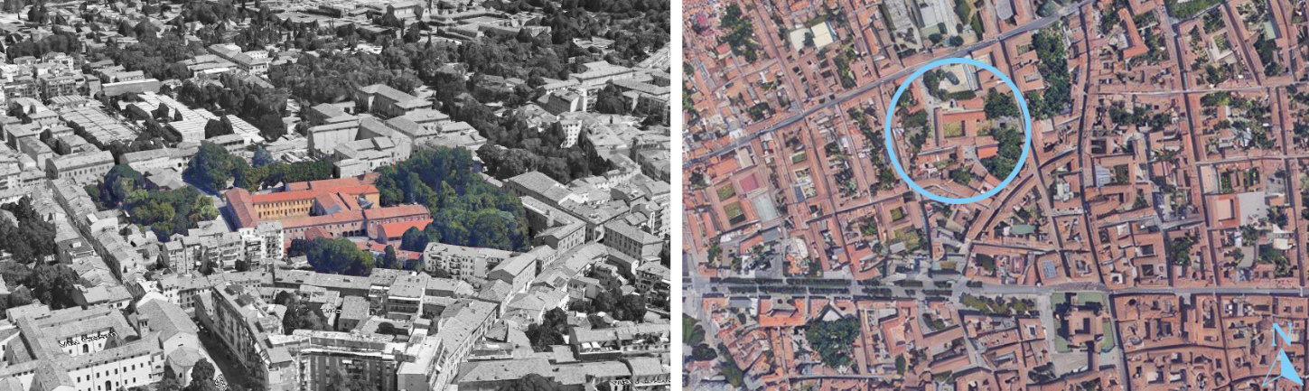
The lack of detailed geometric data at the outset of the project highlights the critical role of on-site inspections in uncovering key planovolumetric features of the building. Consequently, the initial investigations focused primarily on the structure’s chronological stratification. Archival documents were examined to shed light on its original layout, formal characteristics, and geometric configuration, particularly those aspects that have been altered over time. A meticulous review of numerous indirect historical sources housed in the Ferrarese Diocesan Archive revealed several original rooms that had been lost due to substantial architectural transformations. This process enabled the identification of historically significant spaces that had been obscured by the passage of time and successive modifications. To document the current condition of the monastery, data were collected through a comprehensive survey methodology tailored to the site’s distinctive typological and geometric complexity, ensuring increased precision in capturing both the material stratification and the spatial articulation of the architectural organism [3-4]. The primary goal of this documentation strategy was to leverage state-of-the-art technologies and tools, accounting for the site’s specific challenges, while ensuring high accuracy in the survey and data processing phases.
1.2 Research background: TLSs and UASs dataset fusion
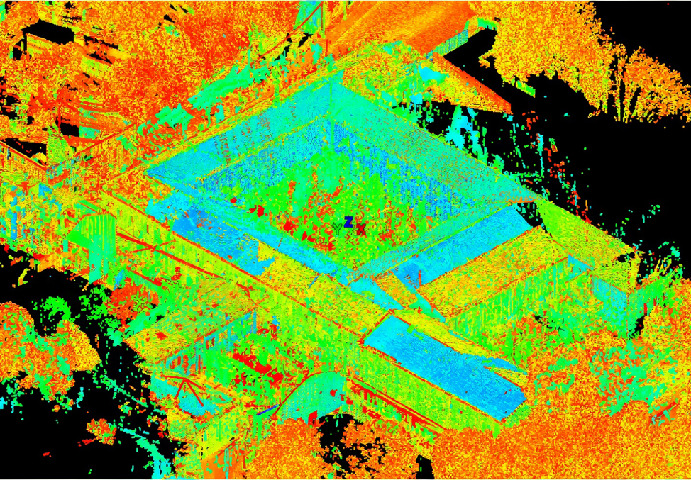
The continuous advancement of technologies such as terrestrial laser scanners (TLSs) and unmanned aerial systems (UASs) has significantly facilitated data acquisition processes. The Leica P40 TLS survey campaign was carried out in two phases: planning and acquisition. More than 200 laser scanner station points were pre-estimated. In situ scans were optimised by room size and complexity. Acquired data were processed in Leica Cyclone r2020.1®, aligned with <4 mm tolerance, and exported after registration into a unified 3D point cloud database. A single three-dimensional coordinate system was then established, with the origin point (Figure 2) located at the centre of the cloister. The point cloud was subsequently decimated and exported in .pts format. To support this operation, due to the large file size and processing demands, the building was divided into four segments: the west wing, the east wing, the south wing, and the former church (Figure 3).
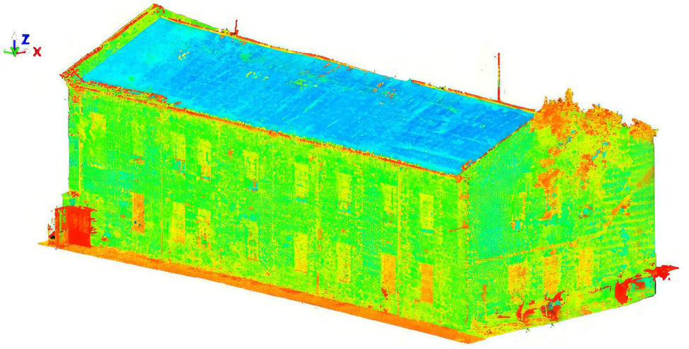
The UAS photogrammetric acquisition was performed using a DJI Mavic 3 Enterprise, with mission planning optimized to achieve a ground sample distance of 4 mm/pixel, suitable for 1:20 scale documentation. Flights were conducted approximately at 20 m altitude for nadir mapping and at distances of 10 m for façade capture, ensuring proper image overlap (≥80%) and minimal angular distortion. Images were processed in Agisoft Metashape Professional r2.0.10, enabling the generation of high-resolution orthomosaics, adaptive textures, and 3D meshes for characterizing the damaged state of the masonries (Figure 4). These datasets were subsequently processed to generate precise and accurate 3D models of detailed objects. However, no single sensor can provide a comprehensive understanding of a large structure, even when multiple scans are conducted [5]. To overcome this limitation, the integration and interaction of both technologies were employed. By geometrically aligning the two datasets, this approach supported the development of a variety of assessment processes [6].
A practical framework that combines UAS photogrammetry and TLS for 3D mapping and monitoring of complex heritage assets has been developed. This methodology integrates ground-based survey techniques and aerial photogrammetry through the CloudCompare v2.12.4 platform, reinforcing its pivotal role in the analysis and interpretation of built cultural heritage [7]. The integration of both methods results in maps, orthophotos, and 3D models. Data fusion enhances the accuracy of 3D representations by combining information from multiple sensors. This process is particularly important for advanced tasks of visualization, typological classification, and quantitative assessment in heritage studies. The choice of data acquisition method depends on factors such as the object’s geometry, surface morphology, required accuracy, and the logistical constraints and financial sustainability of the operation. While various approaches exist, each comes with inherent limitations and operational trade-offs. Terrestrial Laser Scanning (TLS), for example, is restricted by its line-of-sight, which reduces its effectiveness in occluded or confined areas, such as narrow courtyards or interiors with complex partitions. Its performance can also be affected by reflective or absorptive materials, surface moisture, and ambient lighting conditions. Unmanned Aerial Systems (UASs) offer a cost-effective and efficient means of surveying, particularly for capturing high-resolution images of inaccessible zones, such as rooftops, upper cornices, or structures at risk of collapse. However, UAS-derived 3D models can suffer from indistinct textures, radiometric inconsistencies, and a general lack of geometric density in shadowed or reflective areas, reducing their reliability for detail-critical applications. Ground-based digital cameras represent another low-cost solution for 3D modelling. Yet, like TLS, they are constrained by line-of-sight issues and require careful control of camera calibration parameters and network geometry to avoid reconstruction errors.
Given the strengths and weaknesses of each technique, a multi-source and multi-scale integration of data becomes not only advantageous but necessary for generating accurate and semantically rich 3D digital twins. The proposed multi-sensor data fusion method employs a wavelet-based decomposition and reconstruction algorithm to create a refined 3D building model by integrating TLS and UAS datasets. This hybrid approach enhances spatial continuity and surface detail, ensuring both metric reliability and visual fidelity. The TLS dataset was also used to validate the model [8-9], which demonstrated an accuracy of 2.3 mm higher than the TLS-only model, confirming the effectiveness of the fusion strategy in improving both geometric precision and interpretative potential.
2. Damage mechanisms assessment in load-bearing structures
2.1 Built heritage modelling in HBIM environment
The advancement of information technology offers a significant opportunity to transform conventional practices in built cultural heritage conservation and the construction sector. Such an approach is particularly relevant for activities concerning the monitoring and management of existing architectural heritage, where accurate data acquisition and interpretation are essential to support informed conservation strategies and long-term maintenance planning. In this context, the proposed methodology relies on an integrated 3D metric survey as the basis for generating Digital Elevation Model (DEMs), further supported by the development of a Historic Building Information Model (HBIM) [10-12]. This model plays a key role in identifying the most appropriate interventions to improve the structural behaviour of brick masonry elements [13]. Photogrammetric processing, when compared to the geometric database derived from TLS-based point cloud data, proved to be highly effective. It provided accurate working material that enabled a reliable representation of the external surfaces, fully consistent with the building’s actual 3D configuration [14]. The use of as-built BIM techniques in heritage modelling aims to reinforce the relationship between geometric modelling and information management. Among the key attributes considered are temporal evolution, spatial constraints, and damage documentation, all of which contribute to a comprehensive understanding of the building’s lifecycle and inform targeted conservation actions. [15]. In particular, HBIM is well-suited for reconstructing built heritage based on available descriptive data, including historical records, bibliographic sources, archival photographs, and drawings. Analysing the evolutionary and transformative phases of lost architectural elements proves especially valuable, as these aspects directly influence the structural assessment of load-bearing systems, providing critical insights into original construction logic, material discontinuities, and potential weaknesses within the historic fabric. [16]. The monastery is not merely a virtual model. It serves as a critical component of the conservation project, where the various parts of the Dominican cloister complex are transformed into intelligent parametric objects. These elements contain structured relational data as well as detailed quantitative and qualitative attributes. Ultimately, the HBIM model functions as a parametric design environment, capable of storing, updating, and linking information in a coherent and dynamic framework [17].
2.2 Digital elevation modelling
Digital Elevation Models represent the elevation distribution of a terrain or a specific surface in archaeological contexts. They are exported in raster format, allowing each image pixel to be associated with elevation values expressed through a predefined colour scale [18]. In this study, DEMs were employed as analytical tools derived from an indirect survey of the pilot site, which proved to be particularly complex due to its stratigraphic configuration. Unlike their more established application in archaeological excavation analysis, DEMs are still rarely used for studying building façades and even less so in structural assessments [19]. This represents an underexplored field of research.
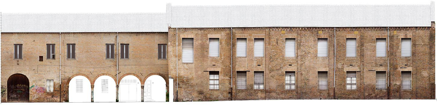
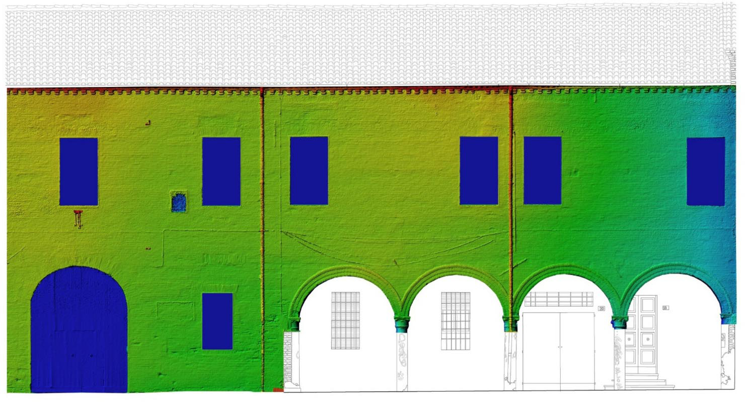
In contrast to horizontal ground strata, the elevations of the masonry walls were visualised through false-colour textures mapped onto vertical planes, offering a detailed representation of their current condition. At the level of architectural interpretation, it became possible to systematise conventional stratigraphic evidence based on materials and construction techniques. Damage patterns affecting the walls were also considered, particularly when they revealed stratigraphic discontinuities that would otherwise be difficult to detect. More importantly, these patterns served as indicators of active structural damage mechanisms. The analysis focused on the southern sector of the monastery, along Via Roversella. Here, a strong correlation emerged between the current condition of the structural elements and the architectural stratification gathered over time.
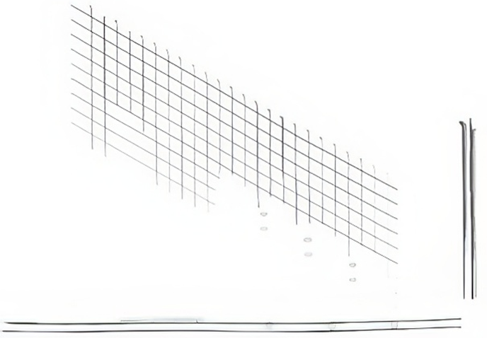
This approach proved especially significant for the analysis of macroelement kinematics within the broader conservation project. The front elevation was analysed by projecting it onto an ideal reference plane. This surface was defined as perfectly orthogonal and aligned through the midpoint of the masonry thickness, allowing a normalised reading of the façade. The method revealed multiple phases of transformation, namely the opening of new windows, the closure of others, and the insertion of intermediate floors associated with changes in use, which were graphically represented and subsequently interrogated from a structural standpoint. In particular, a zone of high concern was identified where an incipient out-of-plane rotation appears to localise, plausibly activated by the thrust transmitted by the roof struts (Figure 5). The evidence from TLS point cloud processing, including systematic slices at 1 m pitch, supports this interpretation and indicates areas of potential concern. To support this preliminary kinematic interpretation, the TLS point cloud was processed through a systematic sequence of horizontal and vertical slices extracted at a constant 1 m pitch, thereby generating a modular grid and the corresponding wireframe representation of the façade. This slicing-based modelling enabled a first-order verification of geometric continuity between the interior and exterior faces, providing evidence compatible with predominantly monolithic behaviour within the wall plane and, conversely, not supporting the presence of non-integrated facing leaves whose differential deformation could promote peak-load-induced local instability. Although the deformation is not readily appreciable along the longitudinal development of the slender masonry walls, the bottom-right overlay of the extracted slices against ideal horizontal and vertical reference lines documents, albeit in a barely perceptible manner, the onset of the rotation mechanism. A more explicit and metrically controlled representation of this phenomenon is provided later in the paper through DEM-based processing, which allows the deformation field to be visualised and quantified with higher sensitivity. The point of most significant structural instability corresponds to two distinct stratigraphic units.
These units reflect a shift in the roofing technique, which also marks the spatial division between the liturgical hall used by cloistered nuns and that intended for laypeople. This architectural modification induced a progressive superficial depression, which became more pronounced over time, ultimately resulting in the current generalised deformation of the façade. The deformation later extended to the entire central section. The case study, the former liturgical hall of the Dominican monastery, is morphologically defined as an assembly space enclosed by structural macroelements: lateral walls, façade, apse, timber trusses, and reinforced concrete floors added during its later adaptation for educational use. These macroelements, collectively, constitute the structural system of the building. Through evolutionary damage analysis, the study identified both unique and recurring collapse mechanisms for each macroelement, many of which are widely documented in the literature. This was achieved using the limit equilibrium method, specifically following a kinematic approach to structural analysis.
The analysis of potential in-plane and out-of-plane damage mechanisms in brick masonry walls has led to notable and insightful results. These analyses are particularly significant, as they aim to evaluate the forces that activate these mechanisms in relation to wall geometry and the dimensional relationships among structural elements [20-21]. The collapse mechanism of a masonry macroelement is typically characterised by the formation of zones with concentrated deformation. These zones separate the macroelement into quasi-rigid blocks that behave kinematically, leading to collapse when subjected to perturbing forces. The initial singularities most likely to generate disaggregation are found at the connection points between macroelements, where the load-bearing structure is most vulnerable. In such zones, relative roto-translations may develop between adjacent elements.
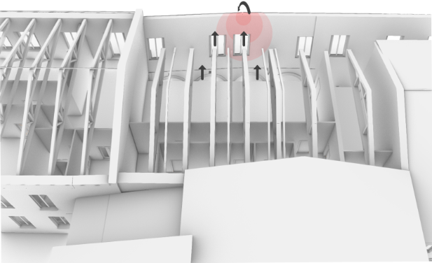
To support the identification of the most appropriate safety interventions, the contribution of DEMs in the evolutionary damage analysis of macroelements is highlighted here. One particularly hazardous behaviour observed is the horizontal flexural deformation of the brick wall, as clearly illustrated by the DEM. In this condition, the masonry wall is joined to perpendicular walls, but its top edge is unrestrained. When subjected to seismic action orthogonal to its plane, the wall exhibits a horizontal arching effect (Figure 6). Specifically, the horizontal thrust from the roof is transferred to the wall. At the orthogonal intersections, this thrust splits into two components: one orthogonal to the wall, which is absorbed by the tie rods of the roof trusses; and one parallel to the wall itself. In the limit equilibrium condition, three hinges typically form, one near the centre of the wall and two at the intersections with the truss ends, where tensile stresses are highest.
The three-hinged isostatic arch becomes unstable when its hinges align. If the wall fails to engage contrasting elements that provide an equal and opposite reaction, the collapse kinematics will be activated. This is the precise condition found in the case under analysis. The wall is held by tie rods but is stressed by the anomalous pushing action of a strut and by the hammering forces of the large roof framing elements. Moreover, the tensile strength of the masonry is reduced, increasing the risk that the material forming the wall’s outer face may detach. This detachment is caused by tensile stresses that develop within the masonry core as part of the kinematic deformation. Additional factors contribute to the onset of horizontal bending mechanisms. These include the presence of aligned openings just beneath the roof band and the quality of the masonry itself, which affects the height of the detachment wedge.
The identification of horizontal bending mechanisms is significantly supported by the DEM, which provides essential information on existing and potentially active macroelements, even in cases where visible damage is minimal. When cracking is not yet present, potential out-of-plane collapse mechanisms may still develop, involving varying extents of the wall surface [23]. However, it remains impossible to determine in advance which kinematic mechanism is most likely to occur. To define the most unfavourable scenario, it will be necessary to assess multiple collapse conditions, each assuming different geometries of the masonry areas involved in the kinematic process [24]. To determine the most unfavourable condition, it will be necessary to assess various collapse factors assuming varying geometries of the masonry regions influenced by the kinematics [25].
3. Result and Discussion
The integration of photogrammetric and TLS data through a multi-sensor approach enabled the generation of a high-resolution digital elevation model, which proved to be a critical tool for identifying early signs of deformation in the historic masonry structures of the Dominican nuns’ compound. Assessing the behaviour of load-bearing structures in built heritage contexts requires both precise 3D geometric modelling and advanced information management systems. These are typically realised through digital twins generated via photogrammetry and laser scanning, alongside semantic knowledge integration using geographic information systems and ontology-based tools [26]. The latest developments in building information modelling (BIM) incorporate both 3D modelling and structured information management [27]. By leveraging the dense spatial granularity of the DEM, the study captured early displacements and strain patterns across the south elevation, which could not be discerned through conventional visual inspection. This finding highlights the diagnostic potential of DEMs in capturing the premonitory deformations that precede the onset of out-of-plane failure mechanisms in historic walls and the development of an explicit crack pattern.
In the specific case of the via Roversella façade, the methodology implemented integrates laser scanning, computer science, Geographic Information System (GIS), and particularly BIM as its foundational components [28]. The false-colour rendering of the elevation data, mapped onto orthogonal projection planes, revealed a subtle yet coherent horizontal flexure extending across the upper third of the masonry surface. This deformation, although imperceptible through traditional surveying techniques, is consistent with the hypothesis of an evolving macroelemental mechanism involving horizontal bending and rotation around the truss anchorage zones. The localised strain concentrations, represented in red and yellow hues in the DEM visualisation, coincide with zones of structural discontinuity historically associated with spatial transitions within the endonartece hall, such as the demarcation between the cloistered and lay areas. This correlation confirms the DEM’s capacity to interpret architectural transformations as potential precursors to mechanical instability. The chronological stratification of the façade, reconstructed through archival analysis and architectural interpretation, provided a more nuanced understanding of its structural behaviour. The area exhibiting the highest deformation was also the segment most affected by 20th-century interventions, including the insertion of reinforced concrete floors and alterations to the original roofing system. These modifications induced eccentric load distributions and altered the thrust paths transmitted by the timber trusses, thereby amplifying the flexural demands on the slender masonry panels. The DEM, in this context, became a medium through which these hidden effects could be quantified and localised with high precision. Notably, the DEM allowed for the anticipation of collapse kinematics by identifying deformation modes before the complete crack pattern associated with the masonry’s settling response manifested. This pre-diagnostic function is particularly significant in heritage contexts, where preventive conservation strategies often need to operate in the absence of overt structural symptoms. The identification of stress trajectories and micro-deformational anomalies supports a predictive understanding of macroelement behaviour, particularly when integrated with knowledge of mechanical discontinuities, construction techniques, and load-bearing hierarchies. In this regard, the study demonstrated that the DEM could simulate an intermediate condition between the as-is configuration and the limit equilibrium state, effectively capturing a transitional phase in the structural lifecycle. This capability is especially relevant for walls exhibiting three-hinged arch behaviour, where the incipient collapse mode is governed by the alignment of hinges and the degeneration of in-plane restraints. The current case study revealed that the pushing action of the roof queen-post timber truss system, compounded by the absence of adequate counter-thrust mechanisms in the longitudinal direction, promoted a partial and localised overturning mechanism in the affected masonry (Figure 7). The DEM detected this deformation as a differentiated surface deflection, offering a direct false-colour visualisation of the deformation gradient along the affected wall surface.
The integration of the DEM into the structural interpretive framework thus represents a methodological advancement that enriches the traditional visual and analytical toolset available to heritage engineers. The use of advanced geometric modelling technologies within HBIM environments enhances the capacity to assess the condition of complex building envelopes. By encoding deformation signals within a continuous digital surface, the DEM bridges the gap between metric data acquisition and structural interpretation, providing an early warning system that aligns with the principles of non-destructive, reversible, and minimally invasive conservation. The approach adopted in this study demonstrates the value of employing DEM analysis not as a post-event mapping technique but as a proactive monitoring strategy capable of influencing decision-making processes in structural conservation.
4. Conclusions and future perspectives
The outcomes of the present investigation illustrate the potential of DEM integration into HBIM workflows as a decisive step forward in the structural diagnosis of built heritage. The ability to capture micro-deformations before the emergence of visible damage redefines the role of elevation models within conservation practice, elevating them from mere representational devices to analytical instruments that can inform structural assessments. This evolution aligns with the overarching aim of preventive conservation: to detect, interpret, and mitigate vulnerabilities before irreversible failure occurs.
A critical implication of the proposed methodology lies in its capacity to embed the DEM as a structured information layer within the broader HBIM environment. This interoperability transforms the DEM from a static visual product into a dynamic data component capable of dialoguing with other informational strata, such as historical documentation, material diagnostics, and performance simulations. In this sense, the DEM becomes a semantic and geometric medium, linking the morphological reality of the building with the predictive logic of structural analysis. The case study has demonstrated that a DEM-enhanced HBIM model can effectively support the identification of stress concentrations, the recognition of stratigraphic discontinuities, and the modelling of localised instability scenarios. By spatialising these phenomena within the digital model, the HBIM environment transcends its original descriptive function and assumes a prescriptive role in defining conservation priorities. The integration of DEM data facilitates this transition by offering a high-resolution understanding of deformations, thereby allowing the simulation of mechanical responses under various boundary conditions and anticipating potential collapse mechanisms.
Future research directions should focus on expanding the use of DEM as a permanent layer in HBIM platforms, moving beyond episodic applications toward systematic integration within digital twins of heritage structures. Such integration requires the development of standardised protocols for DEM generation, classification, and updating, as well as the definition of metadata schemes that preserve the interpretative value of the elevation data over time. The implementation of interoperable data pipelines will be crucial to ensure consistency across software environments and analytical domains. Moreover, the increasing use of IoT-enabled monitoring systems and AI-based anomaly detection tools opens new opportunities for real-time updating of the DEM layer. This dynamic linkage would allow HBIM models to evolve from static repositories of past and present conditions into predictive environments that continuously assess the stability of architectural macroelements. In this context, the DEM could act as a sentinel system capable of issuing alerts when deformation thresholds are exceeded, thus triggering preventive interventions. From a methodological standpoint, the recognition of the DEM as a structural information layer repositions HBIM as a tool not only for documentation and management but also for real-time structural decision-making. The integration of this layer into the HBIM paradigm responds to the growing need for models that are both historically accurate and structurally insightful. This dual capacity enhances the utility of digital models in supporting conservation strategies grounded in material authenticity, structural integrity, and long-term sustainability.
In conclusion, the interoperability between DEM and HBIM systems represents a key vector for innovation in heritage conservation. The ability to integrate elevation-based deformation data within a comprehensive digital model transforms the HBIM into a multifunctional tool that supports design, analysis, and monitoring. This convergence marks a shift toward a more smart and responsive approach to preserving built heritage, one in which structural understanding, digital representation, and conservation action converge within a unified methodological framework.
5. Funding
This contribution aligns with the author’s research focus on deploying advanced digital technologies for the critical assessment of built cultural heritage, particularly in interpreting the successive transformative phases that define long-term historical sedimentation processes. The study adheres to a preventive, risk-informed perspective, emphasising the early detection of latent vulnerabilities and subtle indicators of emerging instability as crucial to mitigation. The research received no external financial support.
6. References
[1] Nieto-Julián JE, Farratell J, Bouzas Cavada M, Moyano J (2022) Collaborative Workflow in an HBIM Project for the Restoration and Conservation of Cultural Heritage. Int J Archit Herit 17(11):1813–1832. https://doi.org/10.1080/15583058.2022.2073294
[2] Barbagallo A, Bonora M, Marchi G (2004) Analisi degli schemi distributivi e strutturali degli edifici ferraresi di culto nei sec. XV–XVIII. In: Fabbri R (ed) Ferrara Architettura 1. Edifici di culto, Ferrara
[3] Tucci G, Bonora V, Conti A, Fiorini L (2017) High-quality 3D models and their use in a cultural heritage conservation project. Int Arch Photogramm Remote Sens Spat Inf Sci XLII-2/W5:687–693
[4] Lagomarsino S (2018) Damage survey of ancient churches: The Umbria-Marche experience. In: Bernardini A (ed) Seismic Damage to Masonry Buildings, 1st edn. Routledge, pp 81–94
[5] Xu Z, Yang J, Peng C, Wu Y, Jiang X, Li R, Zheng Y, Gao Y, Liu S, Tian B (2014) Development of an UAS for post-earthquake disaster surveying and its application in Ms7.0 Lushan Earthquake, Sichuan, China. Comput Geosci 68:22–30
[6] Wu B, Tang S (2015) Review of geometric fusion of remote sensing imagery and laser scanning data. Int J Image Data Fusion 6(2):97–114
[7] Balletti C, Guerra F, Scocca V, Gottardi C (2015) 3D integrated methodologies for the documentation and the virtual reconstruction of an archaeological site. Int Arch Photogramm Remote Sens Spat Inf Sci XL-5/W4:215–222
[8] Moyano J, Nieto-Julián JE, Lenin LM, Bruno S (2021) Operability of Point Cloud Data in an Architectural Heritage Information Model. Int J Archit Herit 16(10):1588–1607. https://doi.org/10.1080/15583058.2021.1900951
[9] Mandirola M, Casarotti C, Peloso S, Lanese I, Brunesi E, Senaldi I (2022) Use of UAS for damage inspection and assessment of bridge infrastructures. Int J Disaster Risk Reduct 72:102824
[10] Yang X, Grussenmeyer P, Koehl M, Macher H, Murtiyoso A, Landes T (2020) Review of built heritage modelling: integration of HBIM and other information techniques. J Cult Herit 46:350–360
[11] Currà E, D’Amico A, Angelosanti M (2021) Representation and knowledge of historic construction: HBIM for structural use in the case of Villa Palma-Guazzaroni in Terni. TEMA 7(1):8–20
[12] Ursini A, Grazzini A, Matrone F, Zerbinatti M (2022) From scan-to-BIM to a structural finite elements model of built heritage for dynamic simulation. Autom Constr 142:104518. https://doi.org/10.1016/j.autcon.2022.104518
[13] Bruno S, De Fino M, Fatiguso F (2017) Historic Building Information Modeling towards building diagnostic data management. A case study. TEMA 3(2):99–110
[14] Fang JW, Sun Z, Zhang YR (2021) TLS-FEM integrated structural deformation analysis on the beamless hall at Nanjing, China. Int Arch Photogramm Remote Sens Spat Inf Sci XLVI-M-1-2021:215–220
[15] Parisi P, Lo Turco M, Giovannini EC (2019) The value of knowledge through h-BIM models: historic documentation with a semantic approach. Int Arch Photogramm Remote Sens Spat Inf Sci XLII-2/W9:581
[16] Adami A, Scala B, Treccani D, Dufour N, Papandrea K (2023) HBIM approach for heritage protection: first experiences for a dedicated training. Int Arch Photogramm Remote Sens Spat Inf Sci XLVIII-M-2-2023:11–18
[17] Bagnolo V, Argiolas R, Cuccu A (2019) HBIM for archaeological sites: from SFM based survey to algorithmic modelling. ISPRS Ann Photogramm Remote Sens Spat Inf Sci XLII-2:57–63
[18] Chukwuma JO, Smit JL (2022) A systematic review and meta-analysis of Digital elevation model (DEM) fusion: pre-processing, methods and applications. ISPRS J Photogramm Remote Sens 188:1–29
[19] Galvez F, Sorrentino L, Dizhur D, Ingham J (2021) Using DEM to Investigate Boundary Conditions for Rocking URM Facades Subjected to Earthquake Motion. J Struct Eng 147(11). https://doi.org/10.1061/(ASCE)ST.1943-541X.0003171
[20] Pantò B, Giresini L, Casapulla C (2024) Discrete macro-models of nonlinear interlocking mechanisms in the out-of-plane failure of masonry walls. Meccanica 60:2019–2031. https://doi.org/10.1007/s11012-024-01883-2
[21] Nale M, Benvenuti E, Chiozzi A, Minghini F, Tralli A (2023) Effect of uncertainties on seismic fragility for out-of-plane collapse of unreinforced masonry walls. J Build Eng 75:106936. https://doi.org/10.1016/j.jobe.2023.106936
[22] Angelillo M, Fortunato A, Gesualdo A, Iannuzzo A, Zuccaro G (2018) Rigid block models for masonry structures. Int J Mason Res Innov 3(4):349–368
[23] Willis C, Griffith M, Lawrence S (2004) Horizontal bending of unreinforced clay brick masonry walls. Mason Int 17:109–121
[24] Borri A, Corradi M, De Maria A (2020) The Failure of Masonry Walls by Disaggregation and the Masonry Quality Index. Heritage 3(4):1162–1198. https://doi.org/10.3390/heritage3040065
[25] Malena M, Portioli F, Gagliardo R, Tomaselli G, Cascini L, Felice G (2019) Collapse mechanism analysis of historic masonry structures subjected to lateral loads: A comparison between continuous and discrete models. Comput Struct 220. https://doi.org/10.1016/j.compstruc.2019.04.005
[26] De Fino M, Galantucci RA, Fatiguso F (2023) Condition assessment of heritage buildings via photogrammetry: a scoping review from the perspective of decision makers. Heritage 11:7031–7066
[27] Falcão AP, Gonçalves AB, Machete R, Silva J, Bento R (2025) Dimensions of interoperability in BIM-supported seismic structural studies: Application to the H-BIM of the chalet of the countess of Edla in Sintra, Portugal. J Cult Herit 72:217–225. https://doi.org/10.1016/j.culher.2023.12.010
[28] Saygi G, Remondino F (2013) Management of Architectural Heritage Information in BIM and GIS: State-of-the-Art and Future Perspectives. Int J Herit Digit Era 2:695–714. https://doi.org/10.1260/2047-4970.2.4.695