Interdisciplinary Method to Analyze Historical Water Resource Management Systems: The Case Study of Masseria del Cristo in Matera, Italy
1 Dipartimento per l’Innovazione Umanistica, Scientifica e Sociale, Università della Basilicata, Italy
2 Institute of Heritage Science, CNR, Potenza, Italy
Email: daniele.altamura@unibas.it; enrico.lamacchia@unibas.it; ruggero.ermini@unibas.it; nicola.masini@cnr.it; marcello.schiattarella@unibas.it
*Corresponding author
Abstract. The rural architecture of Matera preserves important traces of the historical heritage represented by integrated water resources management systems, which contributed to the inscription of the city on the United Nations Educational, Scientific and Cultural Organization (UNESCO) World Heritage List in 1993. The need to guarantee water supply led to theoretical and practical knowledge aimed at sustainable management of resources, both within the urban fabric of the Sassi and along the historical routes of transhumance. The farmhouse known as Masseria del Cristo, in the countryside of Matera, bears historical evidence of this heritage, unlike what is observable in urban areas due to the significant transformations undergone in recent decades. Excavated cisterns, settling tanks, dug channels and a semi-excavated cistern with a roof were detected through photogrammetric processes and represented through 3D digital models that are freely consultable online. Through the analysis of this specific case study, the contribution proposes an interdisciplinary multiscale method to investigate the relationship between historical water systems and the geomorphological and hydrological context in which said systems are located. The results of this process provide a solid starting point to guide proper practices for the protection, recovery and enhancement of this historical heritage.
Keywords: Interdisciplinary Multiscale Analysis, Historical Water Systems, Digital Survey, 3D Virtual Fruition, Rural Architectural Heritage.
1. Introduction
Digitalization processes play a central role in scientific research in the conservation and promotion of cultural heritage.
In recent years, the scientific community has shown a growing interest in developing innovative methodologies and techniques for the survey and analysis of detailed historical heritage information. These processes produce results useful for managing, designing and monitoring restoration interventions and functional recovery, as well as for enhancement and tourist promotion [1].
Structure From Motion (SfM) photogrammetric modeling, which uses frames acquired through cameras mounted on Unmanned Aerial Vehicle (UAV) devices, provides an innovative technology capable of returning high-quality information data, through rapid and simplified processes.
The photogrammetric survey enables the documentation of historical heritage at risk of disappearing and the development of 3D digital models for virtual fruition.
This study structures a multiscale analysis process to analyze systems of interception, channeling, collection and use of the water resource of a historical rural building, known as Masseria del Cristo, in the countryside of Matera (Southern Italy), ensuring its virtual accessibility through online 3D models which represent information banks to transfer knowledge. The choice of this approach stems from the need to properly know the intrinsic characteristics of such heritage, which is the product of historical practices aware of the relationship between architectural scale elements and the wider morphological and hydrological context in which they are located.
The masserie, historical farmhouses, are complex and heterogeneous architectural organisms, which constitute the key elements around the agricultural landscape of Southern Italy, organized on the latifundia and transhumance [2-3], from the Modern Age until the first half of the 20th century.
2. Methods
This contribution presents a methodological approach to study the historical heritage represented by integrated water resource management systems in the area of the Masseria del Cristo, in Matera. The analysis of these systems, inserted in a rural context, which generally have not transformed as in urban areas, provides a systematic knowledge of traditional water supply practices and techniques. The proposed methodology permits to study this heritage through a multiscale interdisciplinary workflow, because the study of water resource management systems requires a broader view at the natural environment in order to understand the close link between human settlement, morphology and hydrology of the territory.
Rural architecture constitutes a substantial and invaluable component of the built heritage, not only within the boundaries of the case study presented but across the entire Italian territory. Until the aftermath of the Second World War, Italy remained a predominantly agrarian society. Consequently, the countryside was not only inhabited but also actively shaped and experienced, often even more intensively than urban areas. This historical condition, which finds parallels in many other European countries, gave rise to an exceptionally rich and diverse architectural landscape. The buildings that populate this landscape draw their distinctive features from a profound and enduring relationship with the surrounding environment.
The case study examined in this research was selected precisely because it embodies this legacy, offering an exemplary testimony to the ingenuity and skill of early builders. These individuals, despite the absence of modern tools and technologies, were remarkably capable of reading the landscape, harnessing local resources, and making thoughtful decisions about where and how to establish a settlement. Their choices reflect a sophisticated understanding of environmental conditions and reveal an inherent sustainability in their approach to construction.
The methodology developed in this study is based on a multi-scalar analysis that considers both the architectural artefact and its broader territorial context. This is achieved through the combined use of different technologies, including UAV devices for detailed architectural surveys and Geographic Information Systems (GIS) for large-scale spatial analysis. The latter makes use of data provided by various public administrations, enabling a broader understanding of the landscape dynamics at play.
Although each heritage site possesses its own unique characteristics, the proposed method proves effective in identifying the common features that define historical rural architecture. These features consist of a body of knowledge, practical expertise, and experiential wisdom that have been accumulated over centuries, allowing communities to develop meaningful and adaptive relationships with the natural environment.
By integrating archival and bibliographic research with architectural surveying, geomorphological and hydrographic analysis of the surrounding landscape, this study offers a comprehensive and interconnected reading of the built heritage. The resulting interpretation highlights causal relationships between the various factors involved, making it possible to understand the rationale behind past settlement and construction choices. These insights remain highly relevant today, providing valuable guidance in an era when environmental sustainability has become an essential goal for contemporary planning and design.
The proposed methodology is structured in the following steps:
1. A bibliographical and archival search that provides relevant information on the subject. The bibliographic search gives a global knowledge of the heritage under study and can provide interesting ideas for the analysis. At the same time, the information acquired through the consultation of historical archival documentation represents a necessary starting point for the next steps.
2. State-of-the-art surveys to acquire an accurate basis on which to carry out the analysis of the historical integrated water management systems.
3. An interdisciplinary multiscale analysis structured in two consequential steps of territorial and architectural research, allowing the case study to be framed within a larger area, identifying the close link between geological, morphological and hydrological characteristics and the integrated water resource management systems. The outcome concerns the detailed study of the different components of the system and their interrelations on an architectural scale.
4. Open source virtual fruition, made possible by selecting a platform on which to implement the 3D model generated in the previous steps, which can be freely accessed by users without any cost.
2.1 Bibliographical and archival research
The study of the bibliography was conducted through the consultation of scientific databases of Scopus, ResearchGate, Google Scholar and supported by the study of unindexed works related to the so-called grey literature. This phase enabled the acquisition of an in-depth understanding of the entire structure and the territorial context in which it was originally conceived. On the one hand, the consulted literature provided valuable insights into the morphological and geological features of the Gravina di Picciano, thus supporting the development of the scientific reflections presented in the subsequent methodological steps; on the other hand, it offered specific historical information regarding the evolutionary phases of the masseria and the functioning of the associated integrated water management systems.
The analysis of documentation enabled the validation of the historical information gathered through bibliographic research and its integration with new insights. This step was conducted through the consultation of several local archives, such as the State Archive of Matera (Archivio di Stato di Matera), the Diocesan Archive of Matera (Archivio Diocesano di Matera) and the RSDI Basilicata (Regional Spatial Data Infrastructure of the Basilicata Region) [4] online web platform. This step provided a solid basis for the analysis of this heritage and its characteristics in order to plan the survey and the analyses carried out at both territorial and architectural scales.
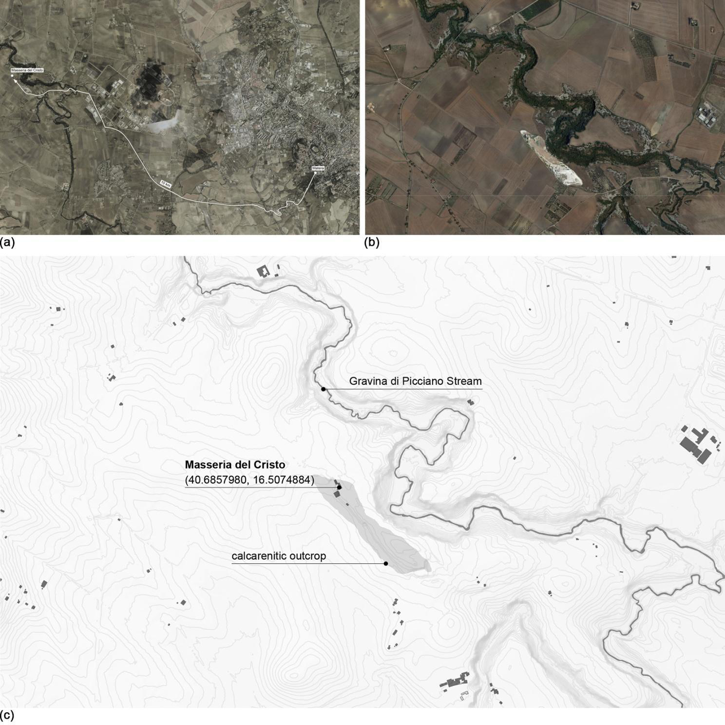
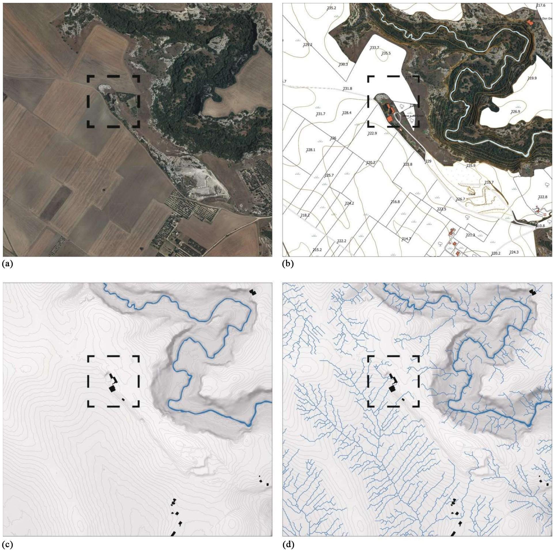
The Masseria del Cristo, or Santissimo Sacramento, stands on the Piano di Chiatamura, a plain area about 10 km west of the urban center of Matera, along a secondary branch of the ancient route from Matera to the Sanctuary of Santa Maria di Picciano, part of a vast network of historical farms and jazzi (typical structures for breeding and sheltering sheep) [5].
This architecture is located in the environmental context of the Gravina di Picciano stream, a left tributary of the Bradano river. The landscape is characterized by the contrast between the harsh bare limestone rocks along the steep banks of the stream and the clay cultivated with extensive arable land and olive trees. The masseria is located on a rocky outcrop exactly on the border between the limestone and clay, a few meters from the edge of the Gravina.
The historical sources related to the Masseria del Cristo appear limited, but they testify to its different configurations over time. Ancient documents call this district Voccuzza, or Boccuzza [5]. In this place, the masseria already appears at the beginning of the 17th century as a property purchased by the Paolicelli family, together with other possessions constituting a large estate, from the previous owner Giacuzzi family, which attests to its previous realization [6].
The probable original configuration of the building is stated in a document dated 11th September 1700 and released by the public officer (tabulario) of the city of Matera, Don Giacomo Antonio Casamassima. In this report, the manor is described as a farmhouse made up of a single brick slab with a pitched roof, a fireplace, an adjacent well and three enclosed courtyards. Construction began in 1706, when ownership passed from the Paolicelli family to the Confraternity of the Santissimo Sacramento of the Cathedral of Matera [6].
The building, used until the mid-20th century, preserves multiple traces of historical construction techniques and ingenious integrated water management systems. The peculiar characteristics and the critical state of conservation and accessibility, as well as the serious risk of definitively losing this heritage, motivated the choice of the case study.
This masseria shows itself in an almost unchanged condition, unlike what can be found in the historical urban fabric of the Sassi, significantly transformed during the recent decades.
2.2 Digital survey
The state-of-the-art analysis is a necessary action to understand the parts that compose a historical building, their characteristics and how they interact to enable the functioning of the whole artifact. The use of innovative technologies for the geometric survey ensures short acquisition times and high precision. For this reason, this study opted to use UAV photogrammetric and traditional survey techniques.
This step needs to be remotely programmed through the integrated software of the drone used or other external software. The on-site survey is carried out only afterwards. To improve the accuracy of the survey, well visible markers for Ground Control Points (GCPs) must be provided. The GCPs shall be evenly distributed in the survey area and well anchored to the ground, and they are intended to constitute the reference for aligning and georeferencing the data acquired. The above images are processed in specific software to obtain point clouds, which are further processed for the purpose of generating 3D digital models. Photogrammetric processes require careful acquisition of the frames, respecting the following parameters and precautions, for ensuring a successful acquisition and an accurate reconstruction of 3D models.
After acquiring all the information necessary to understand the subject, the authors conducted an on-site inspection. The preparation of this investigation directly affects the quality and accuracy of the data that will be collected subsequently.
A preliminary site survey was essential to identify potential interference and disturbance elements that could have adversely affected the acquisition phases. The accessibility of the site, the physical access to the area, the environmental and lighting conditions were assessed (natural lighting should be evaluated to avoid strong shadows and light variations that can complicate image processing) and finally the possible presence of disturbing elements such as crowds or moving elements which could interfere with the instrumentation used in the acquisition step.
Photogrammetric acquisition with UAV necessarily included the consultation of d-flight flight maps to verify airspace categories and determine any restrictions or permits required. The survey was remotely programmed through the integrated software of the drone Autel Robotics Evo II 6K [7], with which the photogrammetric in situ survey was subsequently conducted. To improve the accuracy of the survey, well visible markers have been set up for GCPs.
The GCPs were evenly distributed in the survey area and well anchored to the ground and served as a reference for aligning and georeferencing the data acquired. The acquisition of the frames has respected the following parameters and devices, ensuring the accurate reconstruction of the 3D models: frame overlap between 60% and 80%, both on longitudinal and transverse axis; different camera inclinations, enabling the capture of details that would otherwise remain in shadow; manually setting of shutter parameters, such as aperture, exposure time and ISO, which must be managed manually to ensure uniformity of image exposure; use of frames in their original entirety, without cropping or resizing operations.
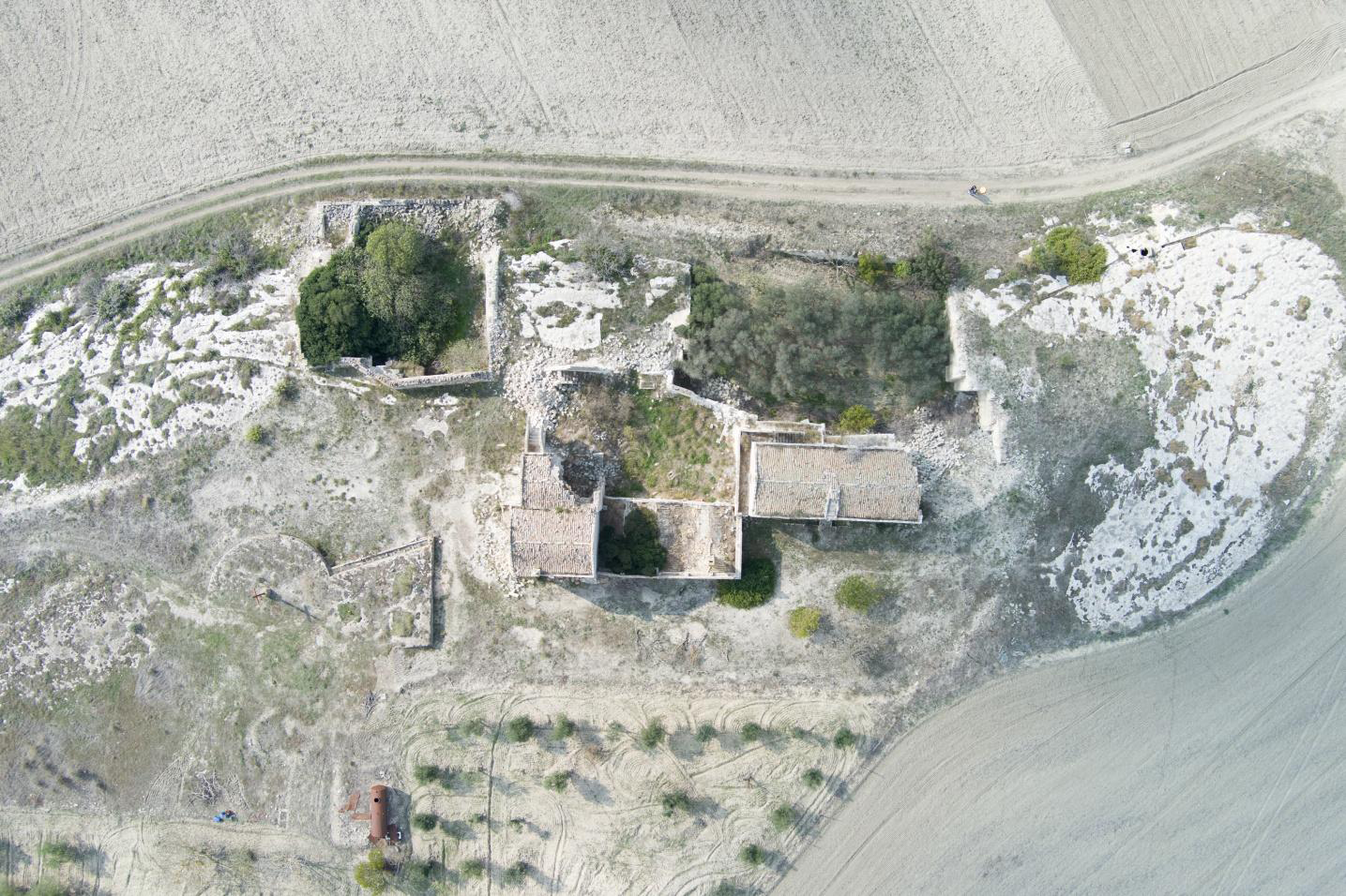
The survey with drones has affected the factory in the farm and the external areas of relevance, for a total area of about 30,000 m2, where a series of structures aimed at integrated management of water resources have been identified. The survey included a first UAV photogrammetric survey and a second traditional survey.
The first one enabled the capture of 1132 frames (Figure 1) and was conducted in the following steps:
1. Automated flight at 50 m from the level of the road access to the area, through which it was possible to obtain photos of context at the territorial scale, with a time of acquisition equal to about 10 minutes;
2. Automated flight at 40 m from the level of the access road to the area of the farm with photographic overlap of 80%, rectangular grid and zenith camera, with a time of acquisition of about 20-25 minutes;
3. Automated flight at an altitude of 20 m from the level of the access road to the area of the farm with a photographic overlap of 60%, rectangular grid and camera with inclination of 45° and with a time of acquisition of about 15-20 minutes;
4. Manual flight of detail at 5-10 m above the level of the road to the area of the masseria with a zenith camera and inclined at 45°, with a scan time of about 20 minutes.
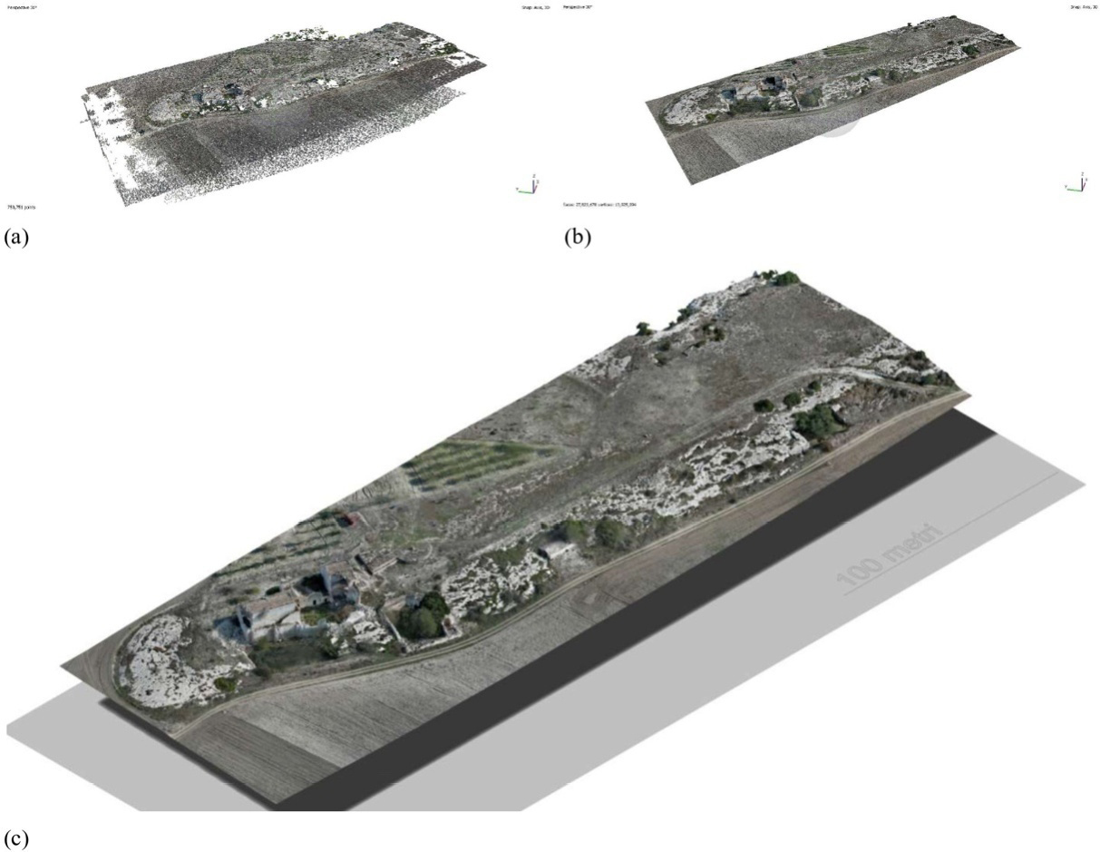
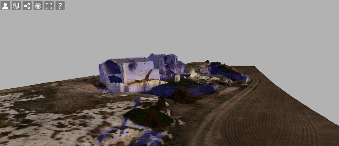
The frames acquired through the previous photogrammetric survey step were processed in order to obtain a point cloud, which was in turn processed through the use of Agisoft Metashape software [8], following a series of basic preparatory steps to extract geometric information from photographs. The images acquired with the drone, as raw as possible and without distortion corrections, were imported into this software, which identifies common points in photographs, calculates, and determines the camera position for each image and optimizes the camera’s calibration parameters. The result of this process is a “sparse point cloud” and a series of camera positions (Figure 2), which afterwards has been processed to obtain the “dense point cloud” (Figure 2), necessary for the generation of the 3D mesh (Figure 2c). Before the generation of the mesh, manual cleaning tools have been used to remove gaps in the reconstruction of the 3D model and correct anomalies. The mesh generation step is the process by which the previously obtained point cloud is transformed into a detailed and optimized 3D mesh using advanced triangulation algorithms (Figure 2).
The inaccessibility of the cisterns excavated into the rocky substrate (Figure 3), due both to the limited size of the intake openings and to their precarious state of preservation, has precluded the use of instrumental survey techniques employing drones or Light Detection And Ranging (LiDAR) systems, both of which require the physical presence of operators within the cistern itself. Consequently, the dimensions of the structures were derived through traditional survey methods using a laser distance meter and applying the triangulation technique. The data obtained reveal dimensions and typological features consistent with those of other similar artifacts found in the area, reflecting construction practices and techniques deeply rooted in the local building tradition [9].

2.3 Interdisciplinary multiscale analysis
To properly understand the intrinsic characteristics of any artefact, it is necessary to look at the context in which it is placed. Similarly, a thorough study of the architectural heritage requires a careful reading of its territorial context.
In the anthropic settlements of this area, the shapes of places guided practices aimed at supplying the resources necessary for survival and water management, leaving indelible traces that bear witness to the technical knowledge of the ancient inhabitants. The presence of complex integrated water resource management systems has led to a methodology that highlighted the relationships between geology, morphology and surface rainwater runoff, enabling the understanding of the path of the surface water and the mechanisms of water resource accumulation.
A multiscale approach was adopted to analyze the functioning of the integrated water resource management system and thus the interrelations between its different components.
The hydrographic analysis was carried out using QGIS software [10], and a model was developed in the GIS environment. Surface runoff accumulation maps were produced starting from the DTM (Digital Terrain Model) data made available by the RSDI Basilicata platform [3]. This analysis permitted the comprehension of the mechanisms of water storage in the tanks, the configuration and operation of the individual components of the system and their interrelations.
The area of Matera can be considered the “physical boundary” between the Matera-Laterza Horst [11] to the north-east (Murge is the geographic name of this type of flat-topped carbonate hills in the Apulian district) and the bas-relief landscape molded in the clays of the foredeep to the south-west [11]. Further, this landscape is characterized by the presence of deep and narrow V-shaped valleys and/or gorges in the strict sense (i.e., with vertical sides), named gravine [12-13]. The Masseria del Cristo is located on a limestone outcrop 10 kilometers from Matera town, at an altitude of 250 m above sea level, not far from the Gravina di Picciano stream (Figure 4).
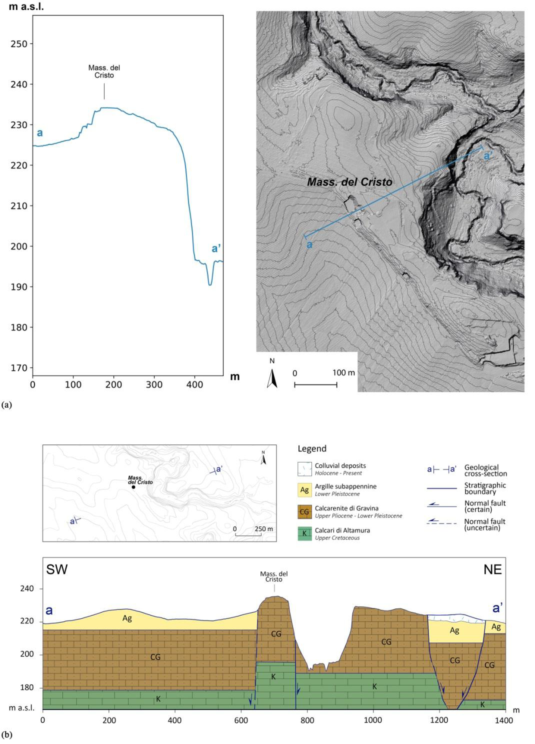
From a geological viewpoint, the study area is entirely included in the foredeep domain (Fossa Bradanica) of the southern Apennines, filled by a marine regressive stratigraphic succession made of clay, sand and conglomerate (from the bottom to the top), early Pleistocene in age. In the surroundings of Masseria del Cristo, the clay formation (Argille subappennine) is largely outcropping, locally covered by a few meters-thick eluvial-colluvial deposits. This formation stratigraphically overlies the bioclastic limestone of the Calcarenite di Gravina, late Pliocene - early Pleistocene in age, cropping out along the sides of the canyon in which the Gravina di Picciano stream flows. Out of the gorge, the calcarenite emerges exclusively in correspondence with the elongated relief trending Northwest–Southeast, upon which the Masseria del Cristo is situated.
Along the Gravina di Picciano, about 5-6 km to the south, the clastic limestone unconformably lies on the Upper Cretaceous limestones Calcari di Altamura, which constitutes the geological backbone of both the morphostructural plateau of Matera and the whole Apulian foreland. Since the Calcarenite di Gravina does not exceed 30-40 m in thickness in the investigated area, a geological cross-section through the site can easily show the entire stratigraphic sequence, here affected by normal faulting [11, 13]. Indeed, the geological and geomorphological analysis reveals the presence of a set of Northwest–Southeast oriented faults, which are responsible for the genesis of the flat spur on which the Masseria del Cristo stands, and which have shaped the distinctive morphology of the area selected for the construction of the structure (Figure 5).
Some straight fluvial segments of the Gravina di Picciano stream display the same orientation (as, for example, the stretch immediately to the south of the limestone hump of Masseria del Cristo), being controlled by the same fault system. This stream is part of the Bradano river basin, which extends from Monte Carmine (Appennino Lucano) to the Gulf of Taranto and originates in the Alta Murgia Park close to the area of La Disperata, within the territory of the Municipalities of Spinazzola (in the province of Barletta-Andria-Trani), Poggiorsini and Gravina in Puglia (both in the province of Bari), at an altitude of 675 m above sea level [14]. The more modest basin of the Gravina di Picciano stream, considered for its lower limit of confluence in the Bradano river, has an extension of 425 km2 and 28% of this is located within the administrative boundary of the Municipality of Matera [14] (Figure 6).
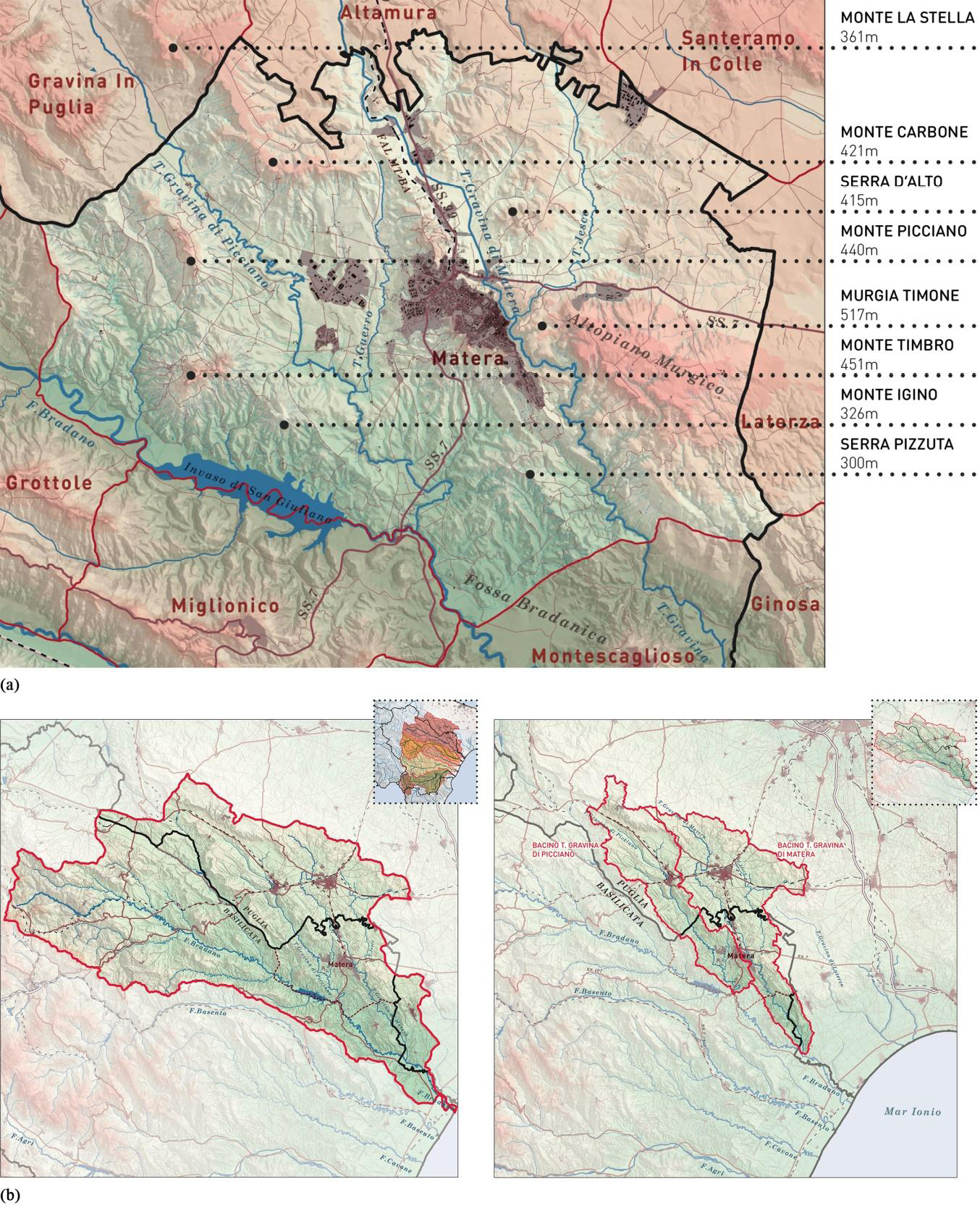
The hydrographic analysis carried out using QGIS software, based on the DTM data provided by the Basilicata Region through the online RSDI Basilicata platform, revealed that the cisterns were built in correspondence with the probable underlying Direct Fault. These cisterns collected meteor water carried by the western waterproof clay surfaces of the Mountains of Carbone, Picciano and Timbro. The produced maps highlighting the relationship between morphology and surface runoff of the meteor water explain the reasons behind the choice of the site for the construction of the Masseria del Cristo. In fact, this building is located on the watershed of the corresponding hydrographic basin, and its position has allowed it to avoid flooding phenomena related to heavy rainfall and to ensure an extended view to control the surrounding territory (Figure 7).
Starting from the analysis and surveys carried out, the subsystems of channeling, collection and use of the resource were identified, which, by using the morphology of the places, guaranteed the water supply (Figure 8). Rainwater is collected on the surface of bare limestone rock, in which channels of variable length are dug, between 20 and 50 cm wide and between 10 and 20 cm deep. These channels convey the water to storage “settling tanks” excavated in a parallelepiped shape of variable dimensions (Figure 8). Maintenance and cleaning were carried out by removing the sampling mouth itself.
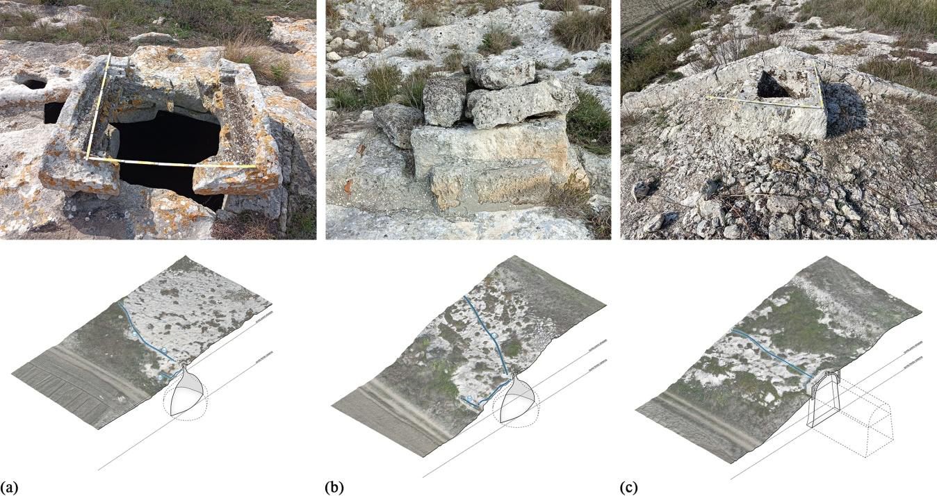
The clarified water is subsequently transferred through other dug channels to three cisterns with an average depth of 6 m. There are two bell-type cisterns (Figure 9a-b) and one semi-hypogeal with roof cistern (Figure 9c).
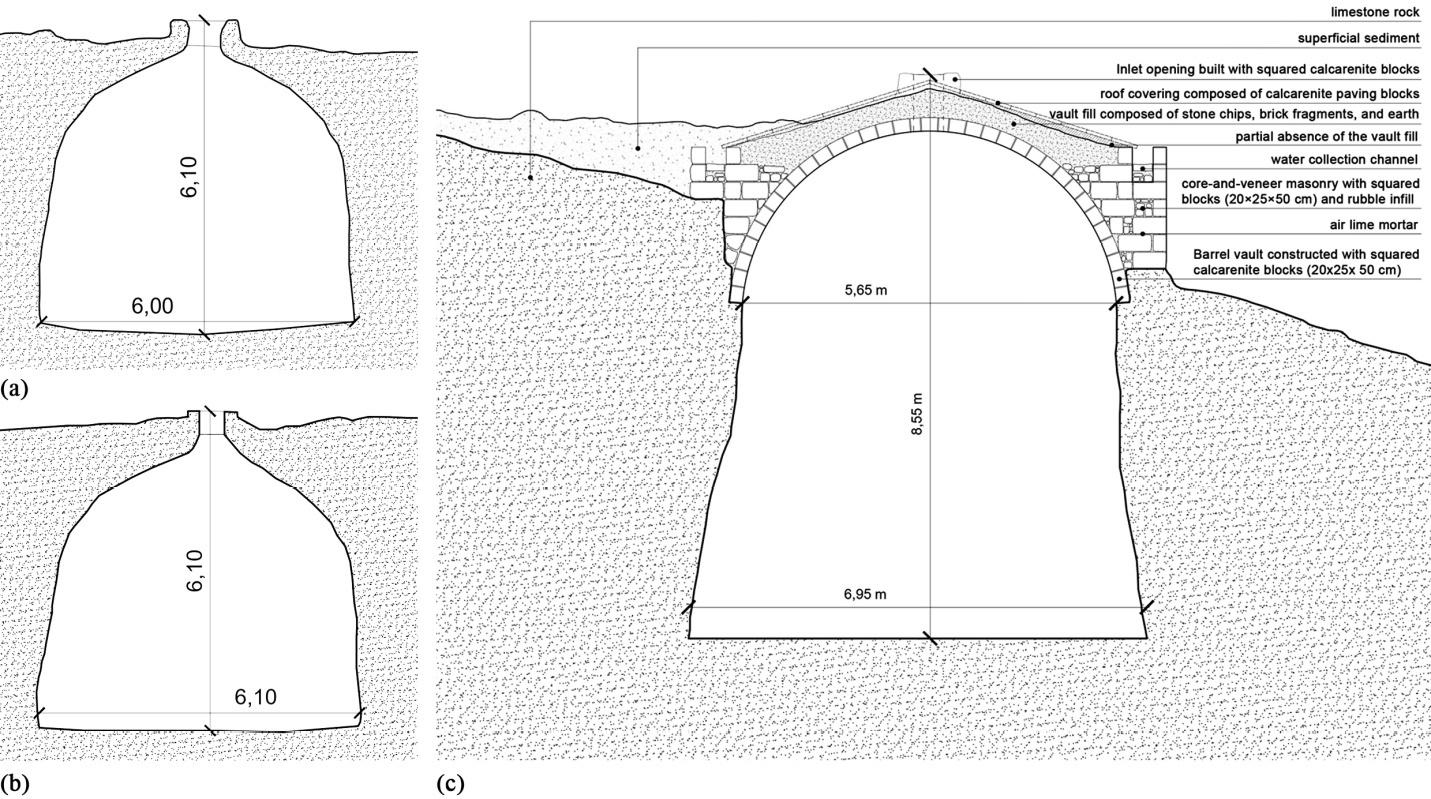
The use of the resource occurred through direct withdrawal from the upper mouths using buckets lowered manually from above. The two bell-type cisterns have an additional duct downstream of their mouth, which transfers excess water through a canal to the drinking trough excavated for animals.
2.4 Open source virtual fruition
The 3D model obtained through the processes described so far, as well as being functional to this specific study, is suitable for methods of enhancement and virtual fruition of this heritage.
In this way, this inaccessible heritage can be explored remotely through a virtual museum experience. Therefore, it was decided to upload it to the ATON open-source platform [15], created by the CNR (National Research Council), which allows users to visualize the model and interact with it in a virtual reality environment (Figure 10).
These tools offer an immersive approach to cataloguing material heritage for scholars and technicians and, at the same time, easy and engaging dissemination to a broad and non-specialized audience. Dissemination in this form is a starting point for raising awareness on the topic of heritage at risk and a guide for valorization processes [16].
3. Discussions
In a general context in which the matrix of architectural shapes has been, for centuries, the adaptation to the natural substrate, each episode has evolved, starting from common practices, towards peculiar solutions. Understanding settlement phenomena on a territorial scale cannot therefore ignore the in-depth analysis of the individual pieces that compose it. This gives rise to the need to identify a research methodology, such as the one proposed in this study, which relates the individual case to its context. The Masseria del Cristo, despite the general precarious state of conservation, shows unaltered examples of systems for interception, canalization, collection and use of water resources of a rural architecture in Matera.
The analysis of historical water systems in the rural territory of Matera offers a valuable testimony to an empirical and profoundly interdisciplinary knowledge, developed and consolidated over centuries within local rural communities. Despite the absence of formal support from modern scientific frameworks, this vernacular wisdom proved remarkably effective in harnessing the geomorphological and geological characteristics of the landscape, thereby ensuring access to the resources needed for the survival and continuity of human settlement. Among these resources, water undoubtedly played a central and strategic role. This is clearly reflected in the sophistication and ingenuity of the systems identified through this research, which reveal a deep understanding of the natural mechanisms governing water circulation. The attention paid to the geological attributes of the context was not accidental but stemmed from precise empirical observations that guided both settlement choices and construction practices.
In particular, the decision to build the Masseria del Cristo upon a calcarenite rocky spur appears to reflect a rational assessment of the site’s hydrogeological dynamics. This elevated position, in addition to offering defensive advantages and visual command over the surrounding territory, provided favorable conditions for intercepting and collecting rainwater and surface runoff. These processes were facilitated by the selective permeability of local lithological formations. The rocky spur, due to its form and composition, thus served not only a defensive function but also played a strategic role in water management, confirming the presence of a form of construction intelligence deeply rooted in the understanding of the environment.
Within this context, geomorphological analysis emerges as an indispensable tool for reconstructing the historical mechanisms of water procurement. The study of rock types and structures, stratigraphic discontinuities, and the permeability and porosity of lithic materials, along with the identification of infiltration and runoff dynamics, permits a scientifically rigorous reconstruction of settlement patterns and resource management strategies developed by rural communities.
In contemporary research, geological studies are essential not only for interpreting the hydraulic techniques of the past but also for evaluating their effectiveness, sustainability, and potential for adaptive reuse in current contexts. Stratigraphic surveys, petrographic analyses, topographical mapping, and digital hydrological modeling highlight the functional principles underlying these systems and the interactions between lithological structures and water flows. When integrated with historical and archaeological data, this knowledge provides a foundational basis for a comprehensive scientific approach to the preservation, restoration, and enhancement of rural hydraulic heritage.
Geology, therefore, not only offers a critical lens through which to interpret historical practices but also serves as a fundamental instrument for guiding informed and context-sensitive interventions aimed at the recovery, valorization, and potential reactivation of these systems. This approach aligns with broader goals of environmental sustainability and cultural continuity.
In this sense, the study of such water systems permits the recovery of meaningful fragments of traditional technical knowledge, as well as contributing to the recognition and appreciation of a form of territorial resilience. This resilience, shaped through a harmonious interaction with the natural environment, has ensured the long-term sustainability of rural settlements in the Matera region.
4. Conclusions
For these reasons, the case study constituted the test bed for validating the proposed multiscale analysis methodology, which can be replicated for further case studies, providing a solid starting point for recovery and enhancement practices. Obtaining a 3D digital model and its interactive online use offers a way to involve and raise awareness even among non-experts on the topic of historical architectural heritage, constituting an innovative method of teaching and dissemination.
The natural evolution of this research points toward the systematic and detailed cataloguing of additional heritage assets and architectural artifacts located within the same territorial context. These elements are to be examined using the same interdisciplinary and multiscale methodology adopted in the current study. Such an extension would permit a more profound understanding of each architectural object, considered in terms of its morphological, typological, and functional specificity. Furthermore, it would enable a more comprehensive interpretation of the relationships that these buildings maintain within the broader networks of settlements, hydraulic systems, and ecological structures embedded in the landscape.
This perspective marks a significant conceptual shift. Cultural heritage is no longer seen as a mere collection of distinct and independent elements, but rather as an organic and interconnected system, deeply rooted in the landscape and reflecting its multifaceted nature, encompassing historical, physical, environmental, and socio-economic dimensions. Within this framework, heritage is redefined as a layered and dynamic palimpsest in which each material component acquires a relational meaning, serving as tangible evidence of a long-standing and layered interaction between human communities and their surrounding environment.
This condition of interrelation represents a fundamental characteristic of historical architecture in general, and of rural architecture in particular. Indeed, the latter embodies a form of deeply grounded construction wisdom that has been developed over centuries and transmitted across generations. It is an empirical and context-sensitive knowledge system, through which past builders devised sustainable solutions that were precisely attuned to the locally available resources and responsive to the geomorphological and climatic specificities of their environment.
Once validated within the context of the present case study, this methodological model proves not only to be transferable but also highly recommendable for application in other territorial contexts. It is grounded in consolidated processes of scientific inquiry and in technologies that are now widely accepted and employed by scholars, professionals, and institutional actors. Consequently, it offers promising avenues for broader applications at national and international levels, promoting an integrated strategy for the interpretation, conservation, and valorization of cultural heritage and landscapes. This approach is capable of reconciling scientific rigor with technological innovation and historical sensitivity, thus fostering a more sustainable and informed framework for heritage management in contemporary scenarios.
5. Author contributions
Conceptualization, methodology, validation, formal analysis, investigation, resources, data curation, writing – original draft preparation, writing – review and editing, visualization, supervision, project administration, funding acquisition.
All authors have read and agreed to the published version of the manuscript.
6. Funding
This work was funded by Next Generation EU - PNRR Tech4You Project “Technologies for climate change adaptation and quality of life improvement”, field of intervention 5. Climate, Energy and Sustainable Mobility, Code ECS00000009 - CUP C43C22000400006 (funds granted to professors R. Ermini and M. Schiattarella, PP4.3.2 - Parks, forests, landforms, rural landscapes, and multifunctional agriculture).
7. References
[1] Fascia R, Barbieri F, Gaspari F, Ioli F, Pinto L (2024) From 3D survey to digital reality of a complex architecture: a digital workflow for cultural heritage promotion. In: Arch Photogramm Remote Sens Spatial Inf Sci. XLVIII-2/W4-2024:205–212, https://doi.org/10.5194/isprs-archives-XLVIII-2-W4-2024-205-2024
[2] Tommaselli M (2006) Il patrimonio rurale materano. Edizioni Altrimedia, Matera
[3] Tommaselli M (1986) Le masserie fortificate del materano. De Luca, Roma
[4] Regione Basilicata (2025) GeoPortale - RSDI Basilicata. https://rsdi.regione.basilicata.it/. Accessed 10 Jul 2025
[5] Lamacchia E (2023) Evoluzione architettonica della Masseria del Cristo o del Santissimo Sacramento in agro di Matera. In: Mathera Rivista trimestrale di storia e cultura del territorio anno VII-VIII nn. 26/27:176–181
[6] Pelosi M (2023) Il latifondo e la masseria di Boccuzza o del Cristo lungo la Gravina di Picciano. In: Mathera Rivista trimestrale di storia e cultura del territorio anno VII-VIII nn. 26/27:170–175
[7] Autel Robotics (2025) Autel Robotics Homepage. https://www.autelrobotics.com/. Accessed 10 Jul 2025
[8] Agisoft (2025) Agisoft Homepage. https://www.agisoft.com/. Accessed 10 Jul 2025
[9] Gambetta G, Statuto A (2016) Matera e l’acqua. Edizioni Altrimedia, Matera
[10] QGIS (2025) QGIS Homepage. https://qgis.org/. Accessed 10 Jul 2025
[11] Tropeano M, Schiattarella M (2019) Un parco geologico urbano per i Sassi di Matera. In: Colonna A, Morelli M, Percoco A, Santochirico V (eds) Sassi di Matera, Per una nuova stagione. Fondazione ENI Enrico Mattei, Milano, pp 160–170
[12] Doglioni A, Simeone V (2019) Gravine: peculiar morphological elements of the landscape in southeast Italy. Ital J Eng Geol Environ Special issue: VI National Congress of AIGA (Matera, Italy):29–32
[13] Beneduce P, Festa V, Francioso R, Schiattarella M, Tropeano M (2004) Conflicting drainage patterns in the Matera Horst Area, southern Italy. Phys Chem Earth 29:717–724. https://doi.org/10.1016/j.pce.2004.03.009
[14] Ermini R, Spilotro G (2022) Letture idromorfiche del territorio: la città di Matera. Casa Editrice Libria, Melfi
[15] ATON (2025) ATON open-source Web3D/WebXR framework by CNR ISPC. https://osiris.itabc.cnr.it/aton/. Accessed 10 Jul 2025
[16] ATON (2025) Link Masseria. https://aton.ispc.cnr.it/s/ISPC_Potenza/20250128-rbz951tnj. Accessed 10 Jul 2025